2017PWIC19.4 (February 28, 2017) - Review of Temporary Conditions for Cyclists and Improvements to Safety (http://app.toronto.ca/tmmis/viewAgendaItemHistory.do?item=2017.PW19.4)
UPDATE! Video embed of PWIC 2017.PW19.4 (click to bottom of page)
By Michael Holloway
Ward 30 Bikes Outreach Coordinator
TTC Leslie Barns Construction Liaison Group
Through the Leslie Barns Streetcar Maintenance Facility track extension street reconstruction on Leslie Street between Queen Street and Commissioners Street (2013 - Ongoing), Ward 30 Bikes advocated 1 for a better level of safety of cyclists and pedestrians in the construction zone; and for high quality detouring of designated bicycle infrastructure through the construction zone.
One of the results of our 3+ years of advocacy (plus blowback from Toronto cyclists community during the Queen's Quay reconstruction and others) was the adoption at the Public Works and Infrastructure Committee (PWIC) of a motion which requested that Transportation Division review protocols for temporary bicycle infrastructure closures (PW5.10 - May 28, 2015 2) - which directed the General Manager, Transportation Services, to liaise with the General Manager, Economic Development, and the Executive Director, Engineering and Construction Services to develop "a protocol to better address cycling infrastructure during road construction, road closures and bike lane closures, including the requirement to install temporary cycling infrastructure and/or cycling detour routes when bike lane closures are required" ... and report back to PWIC.
That report 3 will go before PWIC today, Tuesday, February 28th.
How the Leslie St Reconstruction Impacted Cycling Routes
 |
| 2014-02-14 Looking west from the NE corner of Leslie/LSB |
The construction also impacted north-south recreational egress into and out of Ward 30 for recreational use. Leslie Street is the only roadway that connects north and south to the lake front and the Martin Goodman Trail (Cherry Street also connects - but it originates well west of the ward in Ward 28 and features an extremely inaccessible route due to its alignment through the winding Cherry/LSB intersection).
 |
| TTC Leslie Barns May 2014 configuration W30B 2017 markup |
The construction also impacted the Eastern Avenue Bike Lanes between Rushbrooke Ave. and Leslie - effecting cyclist progress north-south from the end of the Eastern Ave Bike Lanes as well as cycle traffic east of Leslie.
An Overview of the PWIC Report
The Review of Temporary Conditions for Cyclists and Improvements to Safety report basically points out that all the laws and policies - which apply to all vehicles - were simply not being applied when it came to the bicycle mode.
The key recommendation that will make us safer, I believe, is a change to the street closure permitting process:
Under, "Existing City Processes for Temporary Work Zones for Construction and Filming" the report recommends that in the future, drawings detailing detour routes and lane narrowing through construction zones include any designated cycling infrastructure that is present.
From the report:
"Construction
Related Permits For construction related permits, the applicant applies to Transportation Services for a permit for the intended construction related to the delivery of City road works projects, utility works or private developments including some or all of the following:The existing guidance does not highlight the need to indicate bicycle lanes, cycle tracks or bike parking."
- Site plan drawings
- If closures are required as part of the project, a detailed letter must be provided with the application that addresses how the public right of way will be used and a proposed work schedule must be provided for the duration of the closure.
- Specifications of these plans need to include all physical details of the site, including: trees, utility poles, sidewalks, parking meters, street vendor locations and street furniture.
Recommendation:
"Details of existing cycling facilities as part of site plan submission - this will aid in the review of impacts to cycling facilities during the intended construction. Closures that impact streets with designated cycling facilities will include specifics of how cyclists would travel during the proposed closure."
Also from the report, under "Toronto Municipal Code Guidance" - include cycling infrastructure routing changes in the Road Disruption Activity Reporting System (hither-to only applied to motor vehicles):
"Public Information about Planned Closures
"The Road Disruption Activity Reporting System (RoDARS) informs the public of planned roadway closures throughout the city. RoDARS Notification Forms are submitted by applicants following the acquisition of a Street Closure Permit and temporary road closures are approved by the appropriate City staff. Roadway restrictions and specific considerations are included in the application. However, information on bicycle lane/cycle track closures and impacts on these facilities are not identified.
"Pre-construction or construction notices are generated for Major Capital Works in the City of Toronto and are another useful tool to provide information about temporary roadway conditions to the public. For these works, on-site signage may be a requirement of the work zone in order to provide all road users with advanced information on conditions of the road ahead and any requirements for detour."
Recommendation:
"Inclusion in RoDARS Communication - this will help to inform cyclists and appropriate City staff of any planned bicycle lane closures or disruptions and support messaging to the public to communicate about these closures."
Guiding Principles for Cycling Safety in Work Zones
In "Review of Temporary Conditions for Cyclists and Improvements to Safety" 3;
In "Appendix A" 4;
Under section ‘3.’ “Consider Temporary Options for Bicycle Lane/Cycle Track in Work Zones";
Beside letter ‘c.’ (page 4) “Close the Bicycle Lane, Use Temporary Markings to Highlight Cycling Path of Travel in a Shared Lane";
Four bullet points mark the Manager of Tansportation Services' recommendations:
c. Close the Bicycle Lane, Use Temporary Markings to Highlight Cycling Path of Travel in a Shared Lane
• In shared traffic lanes which are less than 3.3 metres in width, shared use lane pavement marking "sharrows" may be installed
at the middle of the traffic lane to provide a message that the lane is shared for limited periods.
• Shared use lane pavement markings should not be used on streets with posted speeds greater than 50km/h.
• Consider reducing posted speed on roadway to <40 km/h if only a shared use lane can be provided. City of Toronto and other municipalities have delegated authority under OTM to reduce speed limits through work zones.
I proposed one change to the recommendations: I propose PWIC amend the fourth bullet point - YELLOW HIGHLIGHT - replace "<40 km/h" with "30 km/h".
Rationale for this proposed amendment:
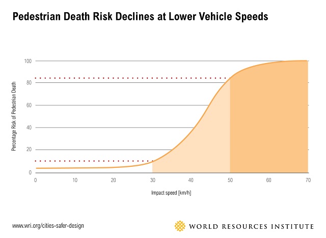
As the report notes, cyclists generally travel at about 20 km/h, therefore in a shared road condition - and especially one where the cycle lane is being temporarily discontinued and cyclists are required to merge with motor vehicle traffic in a shared lane - a posted speed of 30 km/h will create a relatively safe condition and good traffic flow for all modes; is a reasonable policy in the dense urban core (Toronto & East York); is within OTM Book 7 speed reduction guidelines 5; and conforms to Vision Zero recommendations 6.As we know from the Vision Zero research, a person hit by a vehicle going 20 km/h has a MUCH better chance of surviving the collision than a person hit by a vehicle at say, the report's recommended, "<40 km/h" - not to mention the reduced likelihood of a collision happening at all, if the speed limit through construction zones on Major Arterials and Collectors in Toronto's dense urban core were a standard, 30 km/h.
 |
| Chart Image: Pedestrian Death Risk and Vehicle Speed | https://raisethehammer.org/static/images/chart_pedestrian_death_risk_and_vehicle_speed_world_resources_institute.jpg |
Graphic from NYC Vision Zero indicates survivability rates at different speeds:
 |
| Image from TheUrbanist | ICYMI: New York City Implements ‘Vision Zero’ | https://www.theurbanist.org/2014/11/11/icymi-new-york-city-implements-vision-zero/ |
Added to this is the benefit to the City over the long term in lower road maintenance cost if the liabilities that construction companies face while doing City of Toronto contracts are lower due to a marked decrease of on-the-job injury and death from worker/private motor vehicle collisions. Worker injury due to through-traffic is a major concern for the Province of Ontario and the Road Construction Industry 7.
Michael Holloway
Ward 30 Bikes Outreach Coordinator
TTC Leslie Barns Construction Liaison Group
---
Footnotes
1 TTC Leslie Barns Construction Liaison Group | http://www.ttc.ca/About_the_TTC/Projects/Leslie_Barns/Construction_Liaison_Groups.jsp
Ward 30 Bikes' label, LeslieBarns (all Leslie reconstruction advocacy posts 2013 - 2017) | https://ward30bikes.blogspot.ca/search/label/LeslieBarns
2 May 6, 2015 letter to PWIC from Councillor Joe Cressy, Councillor Mike Layton, and Councillor Mary-Margaret McMahon on Ensuring Safety for Cyclists During Construction and Closures (http://www.toronto.ca/legdocs/mmis/2015/pw/bgrd/backgroundfile-80116.pdf) -which was considered at PWIC on May 28, 2015 PW5.10 - Ensuring Safety for Cyclists During Construction and Closures | http://app.toronto.ca/tmmis/viewAgendaItemHistory.do?item=2015.PW5.10
3 General Manager, Transportation Services, February 13, 2017 - Review of Temporary Conditions for Cyclists and Improvements to Safety | http://www.toronto.ca/legdocs/mmis/2017/pw/bgrd/backgroundfile-101365.pdf
4 Appendix A - Guiding Principles for Cylcing Safety in Work Zones | http://www.toronto.ca/legdocs/mmis/2017/pw/bgrd/backgroundfile-101366.pdf
5 OTM Book 7 - Temporary Conditions, section 2.6, (page 48) | http://www.bv.transports.gouv.qc.ca/per/0980389/08_Book_7.pdf
6 World Resource Institute | Ross Center for Sustainable Cities | Cities Safer by Design - July 2015 (page 20 of 104) | http://www.wri.org/sites/default/files/CitiesSaferByDesign_final.pdf (source via Raise the Hammer - April 18, 2016 | Why Vision Zero Calls for a 30 km/h Speed Limit | https://raisethehammer.org/article/2919/?view=flat)
7 In 2012 Ontario Ministry of Labour conducted inspection blitzes at road construction sites to try and mitigate what the Ministry saw as an alarming trend in the increase in worker / private motor vehicle collisions at road-based construction sites (below, see quote from page 1, paragraph 3 - MOL Blitz Results 2012*):
Traffic control
In June, the MOL conducted an inspection blitz on the dangers of working around vehicles and large pieces of mobile equipment at construction sites, including roadwork projects. During this period, 944 orders were issued, 56 of which were stop-work orders. The orders were based on 573 field visits by inspectors. The orders issued most often were for
- lack of protective headgear
- failure to develop and use a traffic protection plan
- failure to ensure workers and employer complied with the Occupational Health and Safety Act and regulations
The MOL chose this issue for its blitz because there had been so many injuries and fatalities in this kind of work. Between 2009 and 2011, four workers were killed or injured on construction sites and roadwork projects and fifteen workers were seriously injured.
* MOL Blitz Results 2012 | https://www.ihsa.ca/pdfs/magazine/volume_13_Issue_1/MOL_Blitz_Results_2012.pdf
UPDATE: Video embed of PWIC 2017.PW19.4
The video is set to start at 1:49:45 when Councillor Janet Davis asks staff about Ward 30 Bikes' proposed amendment to reduce the speed in a shared roadway condition to 30 km/h; report author, Jacquelyn Hayward Gulati, Manager, Cycling Infrastructure & Programs - Transportation Services responds. (Click to 1:39:13 for the beginning of item PW19.4)
mh


