Showing posts with label TTC Community Liaison Group. Show all posts

Tuesday, February 28, 2017

Public Works Report Outlines Better Cycling Infrastructure Protocols During Construction


2017PWIC19.4 (February 28, 2017) - Review of Temporary Conditions for Cyclists and Improvements to Safety (http://app.toronto.ca/tmmis/viewAgendaItemHistory.do?item=2017.PW19.4)

UPDATE! Video embed of PWIC 2017.PW19.4 (click to bottom of page)

By Michael Holloway
Ward 30 Bikes Outreach Coordinator
TTC Leslie Barns Construction Liaison Group

Through the Leslie Barns Streetcar Maintenance Facility track extension street reconstruction on Leslie Street between Queen Street and Commissioners Street (2013 - Ongoing), Ward 30 Bikes advocated 1 for a better level of safety of cyclists and pedestrians in the construction zone; and for high quality detouring of designated bicycle infrastructure through the construction zone.

One of the results of our 3+ years of advocacy (plus blowback from Toronto cyclists community during the Queen's Quay reconstruction and others) was the adoption at the Public Works and Infrastructure Committee (PWIC) of a motion which requested that Transportation Division review protocols for temporary bicycle infrastructure closures (PW5.10 - May 28, 2015 2) - which directed the General Manager, Transportation Services, to liaise with the General Manager, Economic Development, and the Executive Director, Engineering and Construction Services to develop "a protocol to better address cycling infrastructure during road construction, road closures and bike lane closures, including the requirement to install temporary cycling infrastructure and/or cycling detour routes when bike lane closures are required" ... and report back to PWIC.

That report 3 will go before PWIC today, Tuesday, February 28th.


How the Leslie St Reconstruction Impacted Cycling Routes


2014-02-14 Looking west from the NE corner of Leslie/LSB
The long period of construction on Leslie Street forced cyclists to use the FreshCo and Loblaws parking lots to access to the Lower Don Recreation Trail (LDRT), aka - East Lake Shore Trail, one of the busiest cycling routes for bicycle commuters travelling between downtown, east Toronto and Scarborough. The construction also often closed the LDRT across Leslie forcing cyclists to detour through three signaled crossings (east, south and west); and at times narrowed the crossing to 1.5 m wide, forcing cyclists to dismount and walk with pedestrian traffic across Leslie.


The construction also impacted north-south recreational egress into and out of Ward 30 for recreational use. Leslie Street is the only roadway that connects north and south to the lake front and the Martin Goodman Trail (Cherry Street also connects - but it originates well west of the ward in Ward 28 and features an extremely inaccessible route due to its alignment through the winding Cherry/LSB intersection).

TTC Leslie Barns May 2014 configuration
W30B 2017 markup
The Martin Goodman Trail was difficult to get to - often construction hoarding funneled pedestrians and cyclists into a 1.5 m wide passage (that at one point in the configuration had northbound MGT cyclists popping out onto LSB 26 metres east of Leslie into fast moving northbound Leslie to LSB eastbound traffic. (In the spring of 2014 Ward 30 Bikes successfully pushed TTC and Pomerleau to assign a flag person to stop turning traffic for the MGT's Leslie St pedestrian/cyclist crossing).

The construction also impacted the Eastern Avenue Bike Lanes between Rushbrooke Ave. and Leslie - effecting cyclist progress north-south from the end of the Eastern Ave Bike Lanes as well as cycle traffic east of Leslie.


An Overview of the PWIC Report


The Review of Temporary Conditions for Cyclists and Improvements to Safety report basically points out that all the laws and policies - which apply to all vehicles - were simply not being applied when it came to the bicycle mode.

The key recommendation that will make us safer, I believe, is a change to the street closure permitting process:

Under, "Existing City Processes for Temporary Work Zones for Construction and Filming" the report recommends that in the future, drawings detailing detour routes and lane narrowing through construction zones include any designated cycling infrastructure that is present.

From the report:
"Construction

Related Permits For construction related permits, the applicant applies to Transportation Services for a permit for the intended construction related to the delivery of City road works projects, utility works or private developments including some or all of the following:
  • Site plan drawings
  • If closures are required as part of the project, a detailed letter must be provided with the application that addresses how the public right of way will be used and a proposed work schedule must be provided for the duration of the closure.
  • Specifications of these plans need to include all physical details of the site, including: trees, utility poles, sidewalks, parking meters, street vendor locations and street furniture.
The existing guidance does not highlight the need to indicate bicycle lanes, cycle tracks or bike parking."

Recommendation:
"Details of existing cycling facilities as part of site plan submission - this will aid in the review of impacts to cycling facilities during the intended construction. Closures that impact streets with designated cycling facilities will include specifics of how cyclists would travel during the proposed closure."


Also from the report, under "Toronto Municipal Code Guidance" - include cycling infrastructure routing changes in the Road Disruption Activity Reporting System (hither-to only applied to motor vehicles):
"Public Information about Planned Closures

"The Road Disruption Activity Reporting System (RoDARS) informs the public of planned roadway closures throughout the city. RoDARS Notification Forms are submitted by applicants following the acquisition of a Street Closure Permit and temporary road closures are approved by the appropriate City staff. Roadway restrictions and specific considerations are included in the application. However, information on bicycle lane/cycle track closures and impacts on these facilities are not identified.

"Pre-construction or construction notices are generated for Major Capital Works in the City of Toronto and are another useful tool to provide information about temporary roadway conditions to the public. For these works, on-site signage may be a requirement of the work zone in order to provide all road users with advanced information on conditions of the road ahead and any requirements for detour."

Recommendation:
"Inclusion in RoDARS Communication - this will help to inform cyclists and appropriate City staff of any planned bicycle lane closures or disruptions and support messaging to the public to communicate about these closures."


Guiding Principles for Cycling Safety in Work Zones


In "Review of Temporary Conditions for Cyclists and Improvements to Safety" 3;
In "Appendix A" 4;
Under section ‘3.’ “Consider Temporary Options for Bicycle Lane/Cycle Track in Work Zones";
Beside letter ‘c.’ (page 4) “Close the Bicycle Lane, Use Temporary Markings to Highlight Cycling Path of Travel in a Shared Lane";

Four bullet points mark the Manager of Tansportation Services' recommendations:


c. Close the Bicycle Lane, Use Temporary Markings to Highlight Cycling Path of Travel in a Shared Lane
• In shared traffic lanes which are less than 3.3 metres in width, shared use lane pavement marking "sharrows" may be installed
at the middle of the traffic lane to provide a message that the lane is shared for limited periods.
• Shared use lane pavement markings should not be used on streets with posted speeds greater than 50km/h.
• Consider reducing posted speed on roadway to <40 km/h if only a shared use lane can be provided. City of Toronto and other municipalities have delegated authority under OTM to reduce speed limits through work zones.

I proposed one change to the recommendations: I propose PWIC amend the fourth bullet point - YELLOW HIGHLIGHT - replace "<40 km/h" with "30 km/h".

Rationale for this proposed amendment:

As the report notes, cyclists generally travel at about 20 km/h, therefore in a shared road condition - and especially one where the cycle lane is being temporarily discontinued and cyclists are required to merge with motor vehicle traffic in a shared lane - a posted speed of 30 km/h will create a relatively safe condition and good traffic flow for all modes; is a reasonable policy in the dense urban core (Toronto & East York); is within OTM Book 7 speed reduction guidelines 5; and conforms to Vision Zero recommendations 6.

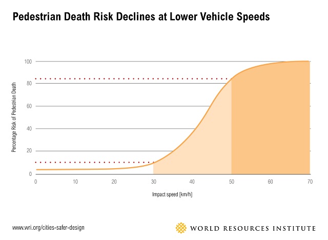
As we know from the Vision Zero research, a person hit by a vehicle going 20 km/h has a MUCH better chance of surviving the collision than a person hit by a vehicle at say, the report's recommended, "<40 km/h" - not to mention the reduced likelihood of a collision happening at all, if the speed limit through construction zones on Major Arterials and Collectors in Toronto's dense urban core were a standard, 30 km/h.


Chart Image: Pedestrian Death Risk and Vehicle Speed | https://raisethehammer.org/static/images/chart_pedestrian_death_risk_and_vehicle_speed_world_resources_institute.jpg


Graphic from NYC Vision Zero indicates survivability rates at different speeds:

Image from TheUrbanist | ICYMI: New York City Implements ‘Vision Zero’ | https://www.theurbanist.org/2014/11/11/icymi-new-york-city-implements-vision-zero/


Added to this is the benefit to the City over the long term in lower road maintenance cost if the liabilities that construction companies face while doing City of Toronto contracts are lower due to a marked decrease of on-the-job injury and death from worker/private motor vehicle collisions. Worker injury due to through-traffic is a major concern for the Province of Ontario and the Road Construction Industry 7.


Michael Holloway
Ward 30 Bikes Outreach Coordinator
TTC Leslie Barns Construction Liaison Group


---

Footnotes


1 TTC Leslie Barns Construction Liaison Group | http://www.ttc.ca/About_the_TTC/Projects/Leslie_Barns/Construction_Liaison_Groups.jsp
Ward 30 Bikes' label, LeslieBarns (all Leslie reconstruction advocacy posts 2013 - 2017) | https://ward30bikes.blogspot.ca/search/label/LeslieBarns

2 May 6, 2015 letter to PWIC from Councillor Joe Cressy, Councillor Mike Layton, and Councillor Mary-Margaret McMahon on Ensuring Safety for Cyclists During Construction and Closures (http://www.toronto.ca/legdocs/mmis/2015/pw/bgrd/backgroundfile-80116.pdf) -which was considered at PWIC on May 28, 2015 PW5.10 - Ensuring Safety for Cyclists During Construction and Closures | http://app.toronto.ca/tmmis/viewAgendaItemHistory.do?item=2015.PW5.10

3 General Manager, Transportation Services, February 13, 2017 - Review of Temporary Conditions for Cyclists and Improvements to Safety | http://www.toronto.ca/legdocs/mmis/2017/pw/bgrd/backgroundfile-101365.pdf

4 Appendix A - Guiding Principles for Cylcing Safety in Work Zones | http://www.toronto.ca/legdocs/mmis/2017/pw/bgrd/backgroundfile-101366.pdf

5 OTM Book 7 - Temporary Conditions, section 2.6, (page 48) | http://www.bv.transports.gouv.qc.ca/per/0980389/08_Book_7.pdf

6 World Resource Institute | Ross Center for Sustainable Cities | Cities Safer by Design - July 2015 (page 20 of 104) | http://www.wri.org/sites/default/files/CitiesSaferByDesign_final.pdf (source via Raise the Hammer - April 18, 2016 | Why Vision Zero Calls for a 30 km/h Speed Limit | https://raisethehammer.org/article/2919/?view=flat)

7 In 2012 Ontario Ministry of Labour conducted inspection blitzes at road construction sites to try and mitigate what the Ministry saw as an alarming trend in the increase in worker / private motor vehicle collisions at road-based construction sites (below, see quote from page 1, paragraph 3 - MOL Blitz Results 2012*):

Traffic control

In June, the MOL conducted an inspection blitz on the dangers of working around vehicles and large pieces of mobile equipment at construction sites, including roadwork projects. During this period, 944 orders were issued, 56 of which were stop-work orders. The orders were based on 573 field visits by inspectors. The orders issued most often were for
  • lack of protective headgear
  • failure to develop and use a traffic protection plan
  • failure to ensure workers and employer complied with the Occupational Health and Safety Act and regulations

The MOL chose this issue for its blitz because there had been so many injuries and fatalities in this kind of work. Between 2009 and 2011, four workers were killed or injured on construction sites and roadwork projects and fifteen workers were seriously injured.

* MOL Blitz Results 2012 | https://www.ihsa.ca/pdfs/magazine/volume_13_Issue_1/MOL_Blitz_Results_2012.pdf


UPDATE:
Video embed of PWIC 2017.PW19.4

The video is set to start at 1:49:45 when Councillor Janet Davis asks staff about Ward 30 Bikes' proposed amendment to reduce the speed in a shared roadway condition to 30 km/h; report author, Jacquelyn Hayward Gulati, Manager, Cycling Infrastructure & Programs - Transportation Services responds. (Click to 1:39:13 for the beginning of item PW19.4)


mh

Saturday, August 9, 2014

Checking the Road Closed construction detouring for Cyclists at Eastern & Mosley

Video - Saturday, August 9, 2014 - 1:07pm
Checking the Road Closed construction detouring for Cyclists at Eastern & Mosley


The latest Leslie Street TTC street reconstruction configuration closes the intersection of Eastern and Leslie until September 7, 2014.

The Road Closed detouring for cyclists on Eastern Avenue at Mosley St was non-existent (as usual) when the new configuration was installed on July 28th.

After two independent walkabouts to study the way road users were using the spaces on July 28th1 and on August 6th2 - plus a @TTCLeslieBarns planned Safety Walk on the evening of August 6th, we now have a pretty good detour configuration for Cyclists.

Thanks go to Ward 30 Toronto-Danforth Councillor Paula Fletcher, who attended the Safety Walk on August 6th; to @TTCLeslieBarns who transmitted the idea concisely and quickly; and to Pomerleau Construction, who executed it perfectly.

Ward 30 Bikes was very disappointed that TTC ignored ideas that they asked us for at the last Community Liaison Group meeting on ways to implement cycling detour routes around the closed intersection on residential streets - detour route signage aimed specifically at cyclists that would have been separate routes from Transportation's suggested detour routes for cars (which are always on main arterial streets).

So - we invited Councillor Paula Fletcher to come to the Safety Walk that was supposed to review all the stuff TTC said they were going to do, but didn't (or couldn't) do.

As some background on this - the present road closure is at Moeley and at Leslie - this is resulting in road users using the Plaza Parking Lots as a detour route. This is mixing cars and trucks and cyclists and pedestrians in a narroew conjested and badly signed areas that are not edesigned to act as roadways - they are parking lots not streets.

The safe way to close this intersection is: - on the west side - Close Eastern at Pape with an egress point for local traffic. On the east side - the last arterial avenue is Coxwell - Eastern should have been closed there with an egress point for local access.

Much pressure from local businesses along this stretch has caused the TTC to do what they've done. The feedback their getting from business is that the businesses would rather have the egress through and by their stores in a congested and dangerous way - so that impulse consumerism will create shopping opportunities for people caught in tha chaos at their front doors.

As I put it to a TTC Leslie Barns representative during the Safety Walk - so your putting consumerism over road user safety?

That what is exactly what they've done.


So thinking on our feet we instead advocated for better detour infrastructure that would encourage cyclists to stay out of the Plaza Parking Lots:

Sketch submitted to TTC Leslie Barns - August 7, 2014


The FreshCo and Loblaws parking Lots are in fact the defacto detour route due to the road closure configuration that TTCLeslie Barns is facilitating by not blocking eastbound Eastern at Pape and westbound Eastern at Coxwell. If they had done that the added benifit would have been safe cyclists routes around Leslie Eastern on Queen and lessened motor vehicle impacts on residential streets north off of Eastern - like at Rushbrooke to West which is getting hammered and at Laing to the East which has been getting halmmer since trhis started in September of 2013 - for example.

So now Ward 30 Bikes suggests that you take the good Bike Lane detouring now open at Mosley and Eastern, and cycle through the Road Closed signage and continue through to LeslieStreet where you should dismount for the short pedestrian walkway that is open on the south side of the intersection there at this time (due to close at some point in the construction phase).


References:


1 Facebook Ward 30 Bikes Page - August 1, 2014 | Cycling Issues - Eastern Avenue Closure (July 28th walkabout) | https://www.facebook.com/ward30bikes/posts/627966513983953

2 Ward 30 Bikes - Wednesday, August 6, 2014 | Another Walkabout of the Eastern Avenue Closure at Leslie Street | http://ward30bikes.blogspot.ca/2014/08/another-walkabout-of-eastern-avenue.html


mh

Wednesday, August 6, 2014

Another Walkabout of the Eastern Avenue Closure at Leslie Street

Wednesday, August 6, 2014 - 12noon to 2pm

Leslie Street reconstruction Site-Walk Notes


I bicycled both eastbound and westbound approaches, and walked the entire site - with special attention paid to the immediate area of Eastern at Leslie.


Eastbound on Eastern from Booth to Leslie:

Signs say only "Eastern Closed at Leslie til Sept. 7th"

One just before Pape, indicates that Pape Avenue is open northbound.

The Larchmount intersection has a northbound left-turn lane and is signaled. After this point the chicane begins making lane changes and left turns, very dangerous.

I concluded that Larchmount is safest Northbound Cyclist's Detour Route.

Inspection of the West-side road closure at Mosley & Eastern - 30 minutes:


On the walkabout portion of the site visit I noted, now ten days into the Closure of Eastern at Leslie - that Rushbrooke is still receiving traffic as a result of a large number of 'emergency' exits off of Eastern - as motorists become aware of the closure just before they get to Rushbrooke. As a result of this surprise situation the Rushbrooke/Mosley/Eastern area is a mass of confusion with vehicles doing U-Turns and stopping short and making sudden turns without looking or signaling. This is further complicated by Traffic Pulses of Cars Exiting the FreshCo Lot - which they are using along with the Loblaws Lot, as a Eastern Avenue Closure Detour Route.

95% of road users on Eastbound Eastern are turning southbound at Mosley and going through the FreshCo/Loblaws Parking lots and back onto Eastern via the east-side Loblaws driveway.

I noted 14 Cyclist road users while at this observation point; 1 of the 14 went straight through and crossed Leslie via the pedestrian walkway on the south side of the intersection (after coming into conflict with a car at the corner of Mosley as she decided to go straight through).


Westbound on Eastern from Queen/Kingston to Leslie:


Signs on Eastern Avenue, East of the Closure are same as in the opposite direction; but no 'last-chance' sign (as near Pape Ave).

Inspection of the East-side road closure at Leslie & Eastern - 30 minutes:


Drivers traveling Westbound along Eastern can see the closure from about 400 metres east of the intersection (past their last exit at Laing) - as a result they are taking the East and West Entrances to the Loblaws Lot and using the parking lot driveway along the North edge to Exit back onto Easter in the opposite direction.

As 'Traffic Pulses' of Cars are coming up the East delivery-way lane - there is some congestion and confusion as people aren't sure where they are allowed to drive. Some try to go southbound along the delivery-way lane which is a One-Way Northbound - as such the placement of the Traffic Guidance Officer at the Entrance/Exit is key.

Over about an hour of observing from both east and west vantage points, I saw 7 cyclists ride up the East-side sidewalk of Leslie North of Eastern Ave to Queen St. Later I walked it - it is a dirty, pot-holed, narrow, winding path --- there is not enough room to walk your bike up this route without coming into conflict with other users - avoid this route with a bike.

AND FOR GOD'S SAKE - DON'T RIDE IT!!!

I also note as above - that on this side of the Closure I recorded 10 Cyclist road users during my time there; 4 of whom were riding on the Eastern Avenue sidewalks (for safety I assume - on this wide, fast roadway with no bike lanes).

Cycling Westbound towards the Closure, I suggest getting off of Eastern at Knox or at Laing. Second most popular route seemed to be the Loblaws Parking Lot West-side driveway, down to the Plaza Intersection - where an Officer is directing all comers through the intersection.


Conclusions:


After 10 days road-users still don't understand what's going on until the last minute as they approach the closure - this is leading to a dangerous mixing of modes especially in the Plaza Parking Lots - but also on the sidewalks in the area. Better signage and clearly marked detour routes for both motor vehicles and for cyclist users (separately) might help reduce dangerous mode mixing and user conflicts.

Perhaps the one simple thing that might accomplish the most good is the closure of Eastern Ave on either side of the closure (leave one lane open; posted Local Traffic Only) . Closing Eastern at Pape Avenue on the West side; and at Laing St on the East side - in this observers opinion - would greatly decrease the dangerous mixing of the three modes - especially in the Parking Lots and at their entrance-ways. This calming of the Plaza's Parking Lots might also draw off cyclists who feel too insecure to ride anything but the sidewalks in the present construction configuration.


A Map - with more notes from this walkabout:

Driving Conditions & Cyclist Detour Routes around Eastern/Leslie Closure

View Driving Conditions & Cyclist Detour Routes around Eastern/Leslie Closure in a larger map


mh

Sunday, June 29, 2014

@CycleToronto @Ward30Bikes Advocacy works - Flagperson on East side Crossing, Leslie/LSB to end of the Leslie reconstruction

Thanks @PaulaFletcher30 - Thanks @TTCLeslieBarns - Thanks Pomerleau construction.


7am to 7pm Monday to Friday until December (living wage and time and-a-half on holidays - and he lives in this neighbourhood).

A hellish job - buy this person a coffee and donuts every morning you commute to work safely with this person's assistance!

I've noticed an incredible increase in cycling on Queen Street this weekend. Just after the closure of Queen at Leslie; and now with World Pride (@WP14TO); and the coming exodus to the northern lakes.

Bike your hood!

We are - by Jennifer Keesmaat's account at Congress4NewUrbanism - Buffalo 2014 (CNU22) - 30,000 daily commuters!

We are a new demographic. We Ride!


Please engage in this.

We are in the midst of a complex, multidimensional cultural revolution in transportation and city building.

Your participation right now will speed the evolution towards good neighbourhoods, sustainable economies, sustainable lifestyles and sustainable identities.

How to make the intersection of Leslie Street and Lake Shore Boulevard a Complete Street - after the Leslie Street reconstruction is finished - remains @Ward30Bikes penultimate concern.

Not just about this Grand Boulevard / Neighborhood intersection - but about these motorways that divide all the neighbourhoods of the The Greater Toronto and Hamilton Area (GTHA) that circle the Great Lakes.


Michael Holloway
Captain, Ward 30 Bikes


References:


Congress4NewUrbanism Keynote - Buffalo 2014 (CNU22)


Note how Tregoning accents statistics; and Keesmaat accents buy-in. They compliment each-other.

Listen carefully.


mh

Friday, May 30, 2014

Lake Shore Blvd / Leslie Intersection, east-side #BikeTO/#WalkTO Detour Crossing STILL a Hazard

I scouted the new construction detours at the Lake Shore Boulevard and Leslie Street Intersection on the evening of Wednesday, May 28 (4:30pm - 6:00pm). On the Friday of the previous week the @TTCLeslieBarns Leslie Street reconstruction detours were moved so that now the north-side Cyclist/Pedestrian intersection is closed - and the south side Cyclist/Pedestrian Crossing is open.

The intersection accommodates the convergence of two important east-west commute cycleways - the Martin Goodman Trail and the Lower Don Recreation Trail - which connect Scarborough and the East Side to the Downtown Core and points west.

BEFORE - South-Side-Closure - Leslie/Lake Shore Boulevard Detour Configuration (since December 2013)

AFTER - North-Side-Closure - Leslie/Lake Shore Boulevard Detour Configuration (reconfigured Friday, May 23, 2014)

Since December 2013 - when the northbound lanes of Leslie Street were closed on the south side of the Intersection I've been doing walk-abouts of this part of the site and taking video of the way Motor Vehicles and Cyclist/Pedestrians are interacting at the east-side Cyclist/Pedestrian Crossing point.

When the south side of the intersection was closed the Crossing came out of a 'doorway' in the construction fencing, 22 metres east of the actual intersection where motor vehicles were actually do the act of turning; 22 metres from where Cyclist/Pedestrian were being beckoned out into the Crossing by the blinking Walk pedestrian sign and Green Cyclist's signal - out into speeding traffic turning eastbound on LSB from northbound Leslie Street traffic flow.

This new configuration does many of the same things.

Close-up of the Leslie/Lake Shore Boulevard Detour Configuration - May 23, 2014

Here's a Video I took of the Cyclist/Pedestrian Crossing on Wednesday, May 28th at 5:30pm:

Note the 'interviewee' says in response to my question, Little scarey corner eh?".

He retorts, "Always".

Leslie and Lake Shore Boulevard - cyclist & pedestrian east-side crossing 5:30pm, May 28, 2014


I have noted - and others have been telling me of late, including the guy in the video - that this corner was dangerous even before the construction detours. When Trial Users coming from the south and from the east approach their northbound crossing right-of-way - vehicles turning from northbound Leslie are looking west on LSB, looking for a spot to slip into the fast flow on red. They don't see the Trail Users - and 'Almosts' happen Every Time you try to cross there with the Cyclist/Pedestrian Crossing signals on green. 

A 'Dutch Intersection' type configuration here would be the solution: A bump-out that forces motorists to slow to a crawl to make the corner - and as a result, come face-to-face with Trail Users as the motorist complete their turn and the Trail Users come to their right-of-way cross point.

South-Side Closure Configuration Problems


In the earlier construction configuration I asked Transportation Services to change the signal phasing to give cyclists and pedestrians a head-start - so they would be in the middle (or through) the intersection when motorists finally rounded the corner eastbound - and thus they wouldn't be as much of a surprise to motorists as they would be plainly visible out there.

I also asked Transportation to consider moving the right-turn Stop Line on Leslie, northbound. right-turn-lane onto eastbound LSB - back from the intersection as much as possible. I suggested moving it back to the usual stop line before the construction configuration (in the old configuration this would have been 17m back from where it was). This I conjectured, would have acted as a Cyclist/Pedestrian Crossing head-start signal phasing - without changing the signal phasing.

I also commented to Transportation Staff that the reason a Cyclist/Pedestrian Crossing user hadn't been hit up to that point was the lucky configuration of the corner there - being as sharp as it was around the retaing wall for the hole in the ground, it - just by happen-stance - slowed cars on that right turn just so that they weren't going so fast that they couldn't stop as cyclists and pedestrians 'popped' out of the construction fencing at the south-to-north entrance to the crossing.

My original idea that I asked Transportation to look into - and the best solution then - and now - is to put a Big Wide Yellow Flashing Crosswalk Sign across the wires supporting the traffic signals right above the east-side Cyclist/Pedestrian Crossing.


The only things done about this since December 2013 were done by @TTCLeslieBarns and Pomerleau, the TTC contractor. They made construction infrastructure changes to provide better sight-lines for pedestrians - so they could see that the intersection was extremely dangerous place to try and cross:
  • More signs,
  • A no right turn sign on read at northbound Leslie,
  • Some slight jigging of the construction fencing,
  • Cutting down of the construction retaining walls between the intersection and the crossing point. 

This - putting the onus on the vulnerable users with right-of-way - instead of what is the proper remedy, to instal infrastructure that tells motor vehicle users they are approaching a Cyclist/Pedestrian Crossing which has right-of-way in this situation.


North-Side Closure Configuration Problems: The Same - or Worse


Now with the North-side of the intersection closed, several new issues arise which put cyclists and pedestrians in the same peril - or worse peril:

Now the southbound lanes of Leslie are open and a left turn are allowed, so motor vehicles can turn eastbound onto L:SB as well as northbound traffic eastbound onto LSB - thus increasing the number of traffic vectors impacting the east-side Cyclist/Pedestrian Crossing.

Plus, now the previously sharp corner at the northbound Leslie right turn lane onto eastbound LSB, is a softer angled turn - so motorists can take the turn at a higher rate of speed as they swing around the corner and accelerate for 22 metres towards the Cyclist/Pedestrian Crossing.


This construction detour configured Cyclist/Pedestrian Crossing is essentially a mid-block crosswalk (on a fast Boulevard) ... Let's sign it that way please.


Michael Holloway
Ward 30 Bikes


Credits - Links

All images are screen-shot edits from the Construction Liaison Groups Meeting #9 Presentation PDF - from Meeting #9, held Thursday, May 1, 2014 at South Riverdale Community Health Centre, 955 Queen Street East.

TTC Leslie Barns - Construction Liaison Group page: http://www.ttc.ca/About_the_TTC/Projects/Leslie_Barns/Construction_Liaison_Groups.jsp

Leslie Barns  & Connection Track - Construction Liaison Group Meeting #9 - May 1, 2014 | http://www.ttc.ca/PDF/Transit_expansion_PDFs/CLG_Meeting-9_May_1_2014.pdf


mh

Tuesday, May 13, 2014

Queen / Leslie Closure could be "#Leslieville Open Streets Weekends" Opportunity

The Queen/Leslie closure detours cars and buses Jones to Greenwood; and Street Cars from Broadview to Coxwell.

The Queen/Leslie closure May  through June, offers an opportunity here in Leslieville to try a Pedestrian Mall on our neighbourhood's Main Street.

Map showing area of  possible "Leslieville Open Streets" Weekends during the Queen St closure

Open Streets Leslieville


Ward 30 Bikes notes that Queen Street from Jones to Greenwood could be seen as a Pedestrian Mall for May and June. Like the "Open Streets" idea that the City is trying this year on Bloor Street from High Park to Sherbourne1 - this is an opportunity to create a vibrant pedestrian centred street for a couple of months.

We note that businesses are likely trying to get as much car traffic into the dead ends on both sides of the blockage - they need the access for deliveries, and for many, not just businesses, off-peak on-street parking.

The Leslieville BIA is planning a Festival in the closure area one weekend in June. Let's expand that good idea.

Every weekend in May and June we could completely block Queen Street - at Jones and at Greenwood - and allow only pedestrian traffic into the area. Businesses could push their business concepts out their front doors and onto the sidewalks in some fashion. People would use the street to walk on - just like the Taste of the Danforth weekend; except this would happen Every Weekend for the duration of the construction closure!

This Open Streets - Taste of Leslieville idea could actually increase business!

Shops all along Queen Street East - and especially from Broadview to Coxwell - are going to experience reduced traffic flows past their font doors during the closure. The Greenwood - Jones area has the advantage that the road is also actually closed. We can take advantage of that and do a Yonge Street style Pedestrian Mall thing for 6 weekends in a row starting this coming weekend!

This is not a half-baked idea out of nowhere from us here at Ward 30 bBikes. This idea is central to our thinking around an idea called "Liveable Cities". Liveable Cities include "Complete Streets" - streets that have narrower traffic lanes, wider sidewalks - and bike lanes. Room on our roadways for more kinds of activities - not just commuter car traffic passing through. An Open Street Weekend is a way to help people vision what a Complete Street could do for a neighbourhood. What a Liveable City might 'feel' like.

The massive highway-like traffic flows on Queen everyday, all through the day (almost) - make Queen the kind of street people like to stay away from if they can help it, during the peak hours. It's only at night when traffic volumes subside that everyone comes out for a casual walk after dinner - or whatever it is they like to do on our neighbourhood's Main Street.

Now we have an opportunity to experience this All Day - Saturday and Sunday - for 6 weekends on a row! If it works, we might even want to expand the idea to Friday's as well!

It is quite likely that this concept just might result in an increase in business on Queen! Locals will come out to support it at first; and then as the news spreads, folks from other neighbourhoods would grab the Bus or Walk or Bike over to Jones - or west to Greenwood - and arrive there just to experience the thing.

Leslieville Open Streets Weekends!

Let's turns this road closure thing on it's head. This is a great opportunity to try something that we couldn't try at any other time - ever.

This is a unique opportunity.

The noisy part of the hole they're making at Queen and Leslie is already almost over. Next comes the task of laying the concrete bed; and then the complex 3/4 Grand track placement - and then more concrete pouring. The street should be relatively quiet these next two months - Especially on weekends!

Come on - let's just do this thing. Leslieville Open Streets Weekends!


1 Toronto Star - Wednesday, April 16, 2014 | Open Streets: pedestrian Sunday on Bloor off to a plodding start | http://www.thestar.com/news/city_hall/2014/04/16/open_streets_pedestrian_sunday_on_bloor_off_to_a_plodding_start.html

Open Streets TO (Original plan: High Park to Withrow Park - scaled back by Council's Economic Development Committee last month) | http://www.openstreetsto.org/

8-80 Cities (one of the sponsors of @OpenStreetsTO) | http://www.8-80cities.org/

Open Streets TO


mh

@TTCLeslieBarns Queen St Closure May 11 to June 21, 2014 - Cyclist & Pedestrian Detours


Queen Street East is closed at Leslie Street until late June 2014.

The Walking Detours


The sidewalks are open on both the north side of Queen and the south side. The south side sidewalk detours south to Memory Lane and then back up to Queen. The north side sidewalk detours north to the lane just behind the Nose Bar - about 1/3 the distance out of your way compared to the south sidewalk route. So your better through-route if your walk is straight through the intersection, east-west, is the north side, sidewalk.

Cyclists have to walk their bikes along the sidewalk with pedestrians. If your not willing to do that - Jones Bike Lanes, Dundas Bike Lanes, and Greenwood Bike Lanes comprise the cycling detour (right).

Here's the Pedestrian Detour Map, a picture I took at Curzon and Queen - north side, May13, 2014.


The Mass Transit Detours


For Bus and Street Car, here's the @TTCLeslieBarns Detour Route map from "Construction Notice May 7, 2014 – Queen and Leslie Intersection Closed" (https://www.ttc.ca/PDF/Transit_expansion_PDFs/LeslieBarns_Notice28_Queen-Leslie-closure_May2014.pdf).

TTCLeslieBarns Map Queen and Leslie Intersection Closure Bus and Streetcar Service May 11 - June 21 2014


TTC Leslie Barns (blog) | https://www.ttc.ca/About_the_TTC/Projects/Leslie_Barns/news.jsp


mh

Tuesday, April 29, 2014

"What she said" - City of Toronto Cheif Planner Jennifer Keesmaat's 'Liveable Cities' narrative

I've been passionate about cycling all my life. I've never had a drivers license, and I've biked everywhere I needed to go; even when I lived in the country as a kid - 10km from my high school.

I've written about and mapped about better cycling routes for years over at Biking Toronto1 But l came into the political process to see if I could help get some cycling infrastructure on the street. Last spring I joined Cycle Toronto and helped a group of us from the old 'SoDa Bikes' Cycle Toronto group 'reboot' the group as @Ward30Bikes - and took on the responsibilities of 'Captain'.

From the very start of this conversation (that's what I've discovered politics is, a massive conversation) I realized I had to refine my vision in order to convince others mine was the way to go. I've never been a 'realpolitik' guy - just shouting the loudest to get mine for me; rather, I had a real good idea of what I didn't like about what our city was - but I had a much harder time enunciating a vision of what I thought Cities could be.

All my writing and reading and research on cycling issues over the last few years has lead me to a school of thought in Urban Planning. The concept is not new2 - but it's not an easy one to express in a few words - it's a complex weave of  understandings in building, transportation, culture, work, policy, play and so on. For the last year I've been studying that school of planning that seems to 'get it' - "The New Urbanism".

This piece reprinted in full below, is by the Cities' Chief Planner Jennifer Keesmaat - published in the Toronto Star on Sunday April 27 2014 - it nails the vision I've been struggling to express. It pertains to everything from Great bike parking in new developments, to wider sidewalks on an East Danforth with bike lanes and connecting neighbourhoods to the water front ... .

"What she said":

By densifying Eglinton, we can fight congestion

The LRT on Eglinton Ave. should be treated not as a transit infrastructure project but as a critical city-building initiative.
A rendering of how Eglinton Ave. will look after the light-rail, which is currently under construction, is finished.
Image: "future_eglinton" visualization - Courtesy of the City of Toronto, via Toronto Star 2014-04-27
http://www.thestar.com/opinion/commentary/2014/04/27/by_densifying_eglinton_we_can_fight_congestion.html


By: Jennifer Keesmaat Published on Sun Apr 27 2014

It’s a well-known fact that it’s not possible to relieve traffic congestion by building more roads in a rapidly densifying city. Research has shown that when we add capacity to our road network, within a very short period of time additional commuters are induced to drive, leading to impassable congestion.

Two University of Toronto professors, Gilles Duranton and Matthew Turner, quantified this phenomena through historical data, showing that road construction goes hand-in-hand with an increase in traffic thanks to the “fundamental law of road congestion.”

We also know that great cities of the world have been able to continue to grow exponentially by planning for movement by adding options or increasing choice. While cycling is just beginning to ramp up in North American cities as part of this recognition of the need to provide more choice and embrace sustainability, the long-time hallmark of a city with choice has been excellent — exceptional, even (think New York City, Paris) — public transit.

But one choice that has the potential to reduce our greenhouse gases while also making our cities safer, quieter and cleaner, critically, is the option to live closer to where we work, and within walking distance or a short transit/cycle ride of the amenities needed for everyday life. Imagine the change in your daily routine if, instead of getting in your car every morning, you tied on your shoes and walked to work.

While it is inevitable that many of us need to travel on a regional scale from time to time, such as to take a vacation, see a specialist or visit families and friends, commuting every day on a regional scale to and from work will always be resource and time intensive — even with high-speed, high frequency transit. If we truly want to reduce congestion, and if we truly care about becoming a more sustainable city, increasing housing choice and affordable housing near the places where people work should be at the top of our city-building agenda.

So when we think about the 19 kilometres of light-rail transit currently under construction on Eglinton Ave., running through the heart of our city, we will miss the mark once again if we treat this investment — and opportunity — as simply a transit infrastructure project, as opposed to a critical city-building initiative.

Densifying Eglinton through midrise development that provides more opportunities for people to live in the heart of the city with high frequency transit access, and as part of walkable neighbourhoods, is about providing housing choice. And more housing choice along key transit corridors is essential to unlocking the congestion puzzle.

But, skeptics may wonder — thinking of the noisy, traffic nightmare that Eglinton is today — is this a real choice? A livable choice? A choice for families? Our avenues will only become desirable, linear neighbourhoods if we reconceive them as complete streets where people move in a variety of ways, including as pedestrians on widened sidewalks lined with shops, medical services, daycares and schools, and separated cycle tracks, as they densify.

We know that the fastest growing demographic in our city — echo boomers, between the ages of 18-34 — are actively trading off a larger house and a long commute for a more urban lifestyle. On the other end of the spectrum, we also know that seniors are downsizing, and in many instances looking for housing choices near the neighbourhoods where they already live. Our avenues, if we get them right, could be home to both of these growing demographics.

Building transit on our existing corridors and leaving them primarily for cars would neglect the opportunity to create these new neighbourhoods, which is as critical to addressing congestion as the transit investment itself. And transit users are pedestrians, so a quality, safe public realm is essential to well-designed LRT.

We must transform our main transit avenues into the future city, the city we desire, the place that we are seeking to become. This future city is comprised of great places to live with a high quality of life where it is possible to walk, shop, cycle to school and take transit to work. It does take some imagining, and some belief, but it will also take tenacity because we have a long way to go.

Jennifer Keesmaat is the Chief Planner & Executive Director of the City Planning Division, City of Toronto.

-----


Reprinted in full - (because she would have wanted it that way).

Read the article at the Toronto Star with all the links and related articles: 

Toronto Star - Sunday April 27th 2014 | "By densifying Eglinton, we can fight congestion" - by: Jennifer Keesmaat | http://www.thestar.com/opinion/commentary/2014/04/27/by_densifying_eglinton_we_can_fight_congestion.html


Notations:

1 Toronto/GTA Bicycle Route Mapping Wiki | Cyclists Sharing Routes around Toronto - http://bikingtoronto.com/bicycleroutemappingwiki/

2 Wikipedia | New Urbanism - http://en.wikipedia.org/wiki/New_Urbanism


mh

Wednesday, April 23, 2014

TTC Leslie Barns Leslie Street Reconstruction - Cyclist & Pedestrian Detour Issues: April 22, 2014 Walk-about

Earlier this week Councillor Paula Fletcher made a request to the community to send it their issues and concerns about the Leslie Street reconstruction.

I sent Councillor Fletcher a synopsis of one of Ward 30 Bikes' outstanding issues: incomplete pedestrian detours through the site - noteably on the East side of Leslie South of Eastern.

Here's a quick map I sent to Councillor Fletcher which notes all the issues (made from the LelsieBarns April Detours Map:

W30B - Pedestrian Deficiencies on the East side of the Leslie Street Reconstruction site --- April 2014 Map I

Here's an UPDATED Ward 30 Bikes Map showing the new configuration - to my knowledge - as of my walk yesterday.

W30B - Pedestrian Deficiencies on the East side of the Leslie Street Reconstruction site --- April 22, 2014 Map II


For the original TTC Leslie Barns map image at the original post, see their blog "April 9, 2014 – Construction Update" at: https://www.ttc.ca/About_the_TTC/Projects/Leslie_Barns/news.jsp (scroll down until you find the entry).


Sidewalk is now Closed


The Sidewalk on the east side of Leslie South of Eastern Avenue is now closed.

Pedestrians are using the Loblaws driveway right from Eastern all the way down to the Plaza Intersection - and through the parking lot and the Burger King Drive-Thu lanes down to the Multi-use Trail on the North side of Lake Shore Boulevard (Lower Don Recreation Trail - LDRT).

Sidewalk closed on the east side of Leslie South of Eastern Avenue Pedestrians using the Loblaws driveway April 22 2014 4-30pm

At the Traffic Island jut to the South of the Plaza Intersection I watched and snapp pics for about 10 minutes. Here are Images taken from about 4:35pm to 4:45pm - in order; none edited out:


         Image 1                  Image 2                  Image 3

         Image 4                  Image 5                  Image 6

         Image 7                  Image 8                  Image 9

        Image 10                 Image 11                 Image 12

        Image 13                 Image 14                 Image 15

        Image 16                 Image 17                 Image 18


(Are those guys speaking French there in the last two photographs - walking through the middle of the Plaza Intersection dressed in executive suits - from Pomerleau?! :)


There must be a way to create a sidewalk here somewhere. Some paint on the parking lot - something.

The same holds true for the parking lot and Burger King Drive-Tru driveway to the south of here; from the Plaza Intersection south to the Multi-use Trail.

Kudos - The Process Works!


Some Kudos for the process are in order:

Wide detour for the Multi-use Trail north side of the intersection, Lake Shore Blvd and Leslie St


Pedestrian Crosswalk East side Leslie at Lake Shore Boulevard


Still looking at the pedestrian crossing - East side of Leslie north-south across Lake Shore Boulevard. The crosswalk lines have just been painted. Makes the crosswalk more visible for turning eastbound traffic coming northbound on Leslie. Hoping for a big yellow crosswalk sign for the summer.

Measured the Stop Line northbound Leslie the construction configuration Stop Line is 13 metres north of the usual non-construction configuration Stop Line. Moving it back gives the crosswalk pedestrians and cyclists more time to get out in the intersection before eastbound turning car traffic starts to turn the corner. Worth a look by Transportation I think.

I made a map image of that idea (sent into Leslie Barns Community Office last week).

TTC_Leslie-Barns Ward-30-Bikes suggestion 2014-04-14 - move northbound Leslie right turn stop-line back to preconstruction position


That's all for this week.


mh

Tuesday, March 18, 2014

@Ward30Bikes 'Pre-Walk' of the @TTCLeslieBarns Public Liaison Committee's - March "Safety Walk"


The Leslie Street reconstruction configuration has changed.


The @TTCLeslieBarns Public Liason Committee is walking the new traffic re-routing as concerns cyclist and pedestrian detours from Queen Street down to Commissioners Avenue tomorrow night (2014-03-19).

To see it in day light - and to linger to see how drivers and pedestrians and cyclists are actually negotiating the new configuration - I walk the site in the day - as I have done four other times earlier in this project.

A Cyclist and Pedestrian 'shooting gallery' on Lake Shore Boulevard


As I noted in video here before (http://ward30bikes.blogspot.ca/2014/02/ttc-leslie-barns-street-reconstruction_14.html) - and at the last meeting of the Public Liaison Committee at South Riverdale Community Health Centre - the East side Multi-use crossing across Lake Shore Blvd is extremely dangerous - especially for northbound cyclists and pedestrians. As I explained before - when the construction moved to the South side of Lake Shore Blvd. on the East side of Leslie Street (from Lake Shore down to Commissioners) - it shifted the northbound Leslie right-turn lane 22 metres to the west from the Cyclist/Pedestrian crossing. No signs were added by City of Toronto Transportation to the roadway, even though the crossing is sitting out in no-man's land. As far as it is from the actual intersection - it is now like an unsigned, mid-block crosswalk on an arterial roadway - except this one is 5 lanes wide and much faster.

Here's a couple of images I took just as I arrived at the corner today at about 5pm.

A cyclists is waiting at the northbound crossing detour from the Martin Goodman Trail to the Lower Don Recreation Trail. I snapped his picture - and then exactly what I've been talking about - happened. By the time I looked up from putting my camera back to capture mode - the first car onto eastbound Lake Shore from northbound Leslie had already driven right through the cyclist's attempt to use the crossing - as I raised my camera to click a shot, the second driver in line turning onto Lake Shore from Leslie had stopped in the crosswalk blocking the egress of the cyclist. The cyclist had to get off his pedals and re-orient his bike so he could get around the nose of the car, that was completely blocking the bicycle/pedestrian crossing. The driver was obviously surprised to see the cyclist there, and had stopped as soon as possible.

Looking south east from the Wendy's Corner at Leslie and Lake Shore - a cyclist waiting northbound, east side of Leslie at Lake Shore Blvd.

Cyclist lifting his bike to negotiate around the nose of a car stopped on the cyclist/pedestrian crossing - east side of Leslie at Lake Shore Blvd. - on the detour of the Martin Goodman Trail that connects it to the Lower Don Recreation Trail (2014-03-18 5:00pm edt)
A few minutes later I walked across the crossing southbound - and meet there at the doorway in the fencing, a woman who was walking her dog - we got talking about how dangerous it felt - and how dangerous it Was. "You really have to be careful here!" she said.

So the crossing sign turns white-walking-man and we begin out into the hail of speed - I'm pointing like we used to do at those arterial crosswalks with the overhead big, yellow and black flashing crosswalk signs - we're walking slowly, on our toes - tentatively out there - to see if they see us.

I'm pointing, she's pointing - the dog is a Rottweiler/Doberman cross - but he's pointing too!

The first car doesn't stop; doesn't even slow - he really didn't see us. The next one does - finally - after slowing and then suddenly realizing it's a Crosswalk, stops short.

Wow!

I saw this kind of thing 3 times in 1/2 an hour here - watch the video (I narrate 4 times but the guy in the yellow jacket has no conflict as no one was turning on that signal cycle at the moment he crossed) - the guy with the two dogs had to stop; the woman and I had to stop; and the original above - the cyclist in the pictures - had to stop.

At the last Construction Liaison Committee meeting Martin Maguire from Transportation  indicated - it seemed to me - that Transportation would look into giving the crosswalk a 6 second head start ahead of the green light northbound Leslie --- and Pomerleau said they'd see about taking down all the stuff in the way of pedestrians line of sight looking westbound as you proceed North out of the construction fencing, 'doorway'.

Someone said they should do one at a time. I retorted that I thought we should do both at once.

As per my request, the 6 second head start for cyclists doesn't seem to have even made it into Transportation's 'Action Items' list (only note about Leslie/LS: Nov 2013 signal length change - page 2/4 - http://www.ttc.ca/PDF/Transit_expansion_PDFs/LeslieBarns_City_Transportation_Update_Mar6_2014.pdf).

 :/

For their part, Pomerleau have taken down the blue tarp around the North end of the Leslie, South of Lake Shore Construction zone - and moved back the fencing to try and improve Westerly sight-lines - so much so, that even a section of broken road is visible outside the fencing now ... BUT - you still can't see cars coming, there is too much lineal fence mass in the way ...

And, as the stories I related above show quite well I think,

PEDESTRIANS AND CYCLISTS NEED A HEAD START!


I'm afraid - as the volume of Trail users grows with the weather turning warmer and warmer; and the evening light significantly longer all of a sudden - that the probability that someone is going to get hit at this spot is arcing up to 1:1 really fast. Cyclist volumes on the Trail have doubled since January. I saw three walkers off the Trail in the 20 minutes that I was there today. Zero in January when I was there for 3/4's of an hour.

Weather today - 2014-03-18 - at 17:00 edt: 0°C, Wind 28km/h - Wind Chill: -7°C
http://weather.gc.ca/trends_table/pages/ytz_metric_e.html
(a dynamic page - for this data in the future see 'historical weather')

I took a couple of videos of the pedestrian/cyclist 'shooting gallery'.

I began to shoot this video in the same traffic signal cycle as in the 2 photographs above (of the cyclist in conflict on the crossing) - you can see the pink cement truck from the images pull off the light at about 30 seconds in):

Northeast corner of Leslie/Lake Shore Looking South - 2014/03/18 17:00 edt


Northwest corner of Leslie/Lake Shore looking Southeast - 2014/03/18 17:10 edt


__________________


Some less bad news for pedestrians; the East-side sidewalk from Eastern Avenue southbound, is still a sidewalk to nowhere. Cyclists and Pedestrians (by the tracks in the mud) are using the one-way southbound driveway in order to walk South.

East side of Leslie, South of Eastern - a sidewalk to nowhere

Good News!


The Plaza Entrances Intersection now has a separated pedestrian crossing!

Plaza Intersection separated pedestrian crossing - looking West from the Loblaws Parking Lot...

.. unfortunately, it's not all that intuitively placed - or something.


I watched people use this intersection for about 1/2 an hour. Coming from the North down the West-side sidewalk; or across the North edge of the FreshCo Parking Lot - the crossing does appear to work. The entrance way into it, and it's position in the landscape is understood by those approaching it.

But from the East, from the main island at the Loblaws Grand Entrance for example - or from the parking lot to the Southeast, or south up from Burger King, or a hike on the Lower Don Recreation Trail - all you see is a jumble of road cones. Your mind doesn't see a Pedestrian Crossing.

I think the smaller, thin cones would work better along the line separating traffic and people. That might better high-light that it is a Pedestrian Way.

Perfect capture of what I saw. Every time someone approached from the East they didn't see the crosswalk. A man walking westbound in the car lanes, doesn't see the pedestrian crossing.
A woman and two kids coming from the East, they find their way intuitively.


Next I walked across the pedestrian-way and took up a viewing station on the West side. Immediately I saw people walking across on the South side of the Plaza Intersection.

As I watched for about 5 minutes, and after a number of people did the exact same thing - I realized that all those coming from the South along the West-side sidewalk - and those coming across the parking lot from the Southwest - were walking into the intersection from the Southwest corner and across the South side of the intersection.

I think I figured out why; this series of five images describes it nicely:


1. Pedestrian Route inadvertently leads pedestrians into danger. West-side sidewalk, woman walking northbound towards the Plaza Intersection

Image 1


2. The same woman walking towards the intersection a couple of seconds later... .

Image 2


3. You can just see her behind the sign stepping into the Plaza Intersection from the South-West corner curb area (where the crosswalk normally is when Leslie Street is open).

Image 3


4. Now you can see she's walking diagonally across the intersection towards the North-East curb and the sidewalks that lead to the Grand Entrance into Loblaws (or the one-way southbound driveway that doubles as a sidewalk on the West side of the store).

Image 4


Here's why. 

I followed up to the spot where she stepped into the intersection and took a picture of the panorama. I marked up this image. The curb cut, the non-slip grooves - and the vista in front - all say, 'Walk This Way!!!'

Image 5


I didn't mark it on 'Image 5' - but where the purple line meets the sand bags on the right, you can see that the fence just happens to be on the same line. It helps inadvertantly, to indicate that this is where one is supposed to walk!

Perhaps Pomerleau can square it up a bit; that will also slow cars down around the turn there - which is a good thing.

But I think the ultimate solution is to run the cones along the edge of the West-side sidewalk, all the way to the point where cars and trucks out of the FreshCo Plaza make their turn southbound.

The cones should be connected with yellow tape (like the crosswalk); and a sign added: "Pedestrians use North-side Pedestrian Crossing" ... with a map of the intersection perhaps, and a big "Cross Here!" pointer arrow.

That's it for the Pedestrian gauntlet at the Plaza Entrances.


Here's some concrete cut-offs that were left in a snowbank by accident one snowy day. Now as the snow recedes, they're a trip hazard. Northwest corner of Leslie and Lake Shore.

Watch your step, Northwest corner, LS & Leslie


That is all.

Walking it with the Committee again tonight (Wednesday, March 19th 2014).


mh