Our cycling advocate friends to the west and north of us recently sent a joint letter to several councillors and the mayor. They requested for safety improvements on Bayview. When you look at the map, it's quite striking how fragmented and incomplete the infrastructure is now. Please consider writing to the below councillors today in support of this.
To: Councillors John Burnside, Mary Fragedakis, Pam McConnell, Jaye Robinson, Kristyn Wong-Tam
CC: Councillors Josh Matlow, Christin Carmichael-Greb, Mayor John Tory
June 5, 2017
In light of thehorrific and entirely preventable death of a 5-year-old on Lakeshore Blvd last week, we request the rapid installation of safety barriers onBayview Avenue between Pottery Rd and Moore Ave, and the initiation of a safety study - emphasizing cyclist safety - of Bayview Avenue over its entire route from Moore Ave to River St.
Bayview has been identified as a priority cycling corridor for over 20 years. Bayview is the only on-street cycling connection from Midtown, North Toronto and Leaside to the Lower Don Trail system, the Don Valley Brickworks, and downtown either via Rosedale and the Sherbourne bike lane or via River St. This route is used by thousands of young and old people who ride bikes, from experienced riders to families out on a leisurely ride. This route is also used by speeding motorists as though it were a major expressway, despite Bayview being designated as a city road. Evidence strongly shows that motorist speed is directly linked to collision frequency and severity, therefore this higher-speed corridor presents a high risk to cyclists.
City Council in 2005 endorsed the Don Valley Corridor Transportation Master Plan, which recommended a full Environmental Assessment for Bayview. Unfortunately, this study was never completed.
In 2016 the City reconstructed the roadway between Rosedale Road and Moore Avenue which included (1) installation of a guardrail on the east side ofBayview, between Rosedale Valley Road and Pottery Road and (2) widening of the paved shoulder from Pottery Road to Moore Avenue, so that it is in effect a bike lane. Unfortunately, no guardrail was installed north of Pottery Rd, and simply widening the shoulder is an inadequate safety measure.
Also in 2016 Councillor Fragedakis tabled a motion, approved by Council (2016.MM18.10) for a functional study of Bayview including cycling safety. Unfortunately we learned earlier this month that City staff aren't even preparing to start this study.
This is unacceptable. We don't need to wait for tragedies like this to happen before we install basic safety features such as guardrails on bike routes next to high-speed roadways.
Therefore we recommend to:
Designate Bayview Avenue from Pottery Rd to Moore Ave as a cycle track, in accordance with the City’s 2016 Cycling Plan.
Separate the new bikeway from the roadway using appropriate technology such as guardrails or Jersey barriers.
Service the new bikeway to cycle track standards (regular sweeping, pothole repair, snow clearing, etc).
Request Transportation Services to report how additional safety measures on Bayview Avenue between River St and Moore Ave can be addressed, including extending the bikeway south from Rosedale Valley Rd, widening the paved shoulder further, and closing the gap southbound between Moore Ave and Nesbitt Ave.
Fully engage with the cycling community as a stakeholder during the City study.
By Michael Holloway Ward 30 Bikes Outreach Coordinator TTC Leslie Barns Construction Liaison Group
Through the Leslie Barns Streetcar Maintenance Facility track extension street reconstruction on Leslie Street between Queen Street and Commissioners Street (2013 - Ongoing), Ward 30 Bikes advocated 1 for a better level of safety of cyclists and pedestrians in the construction zone; and for high quality detouring of designated bicycle infrastructure through the construction zone.
One of the results of our 3+ years of advocacy (plus blowback from Toronto cyclists community during the Queen's Quay reconstruction and others) was the adoption at the Public Works and Infrastructure Committee (PWIC) of a motion which requested that Transportation Division review protocols for temporary bicycle infrastructure closures (PW5.10 - May 28, 2015 2) - which directed the General Manager, Transportation Services, to liaise with the General Manager, Economic Development, and the Executive Director, Engineering and Construction Services to develop "a protocol to better address cycling infrastructure during road construction, road closures and bike lane closures, including the requirement to install temporary cycling infrastructure and/or cycling detour routes when bike lane closures are required" ... and report back to PWIC.
That report 3 will go before PWIC today, Tuesday, February 28th.
How the Leslie St Reconstruction Impacted Cycling Routes
2014-02-14 Looking west from the NE corner of Leslie/LSB
The long period of construction on Leslie Street forced cyclists to use the FreshCo and Loblaws parking lots to access to the Lower Don Recreation Trail (LDRT), aka - East Lake Shore Trail, one of the busiest cycling routes for bicycle commuters travelling between downtown, east Toronto and Scarborough. The construction also often closed the LDRT across Leslie forcing cyclists to detour through three signaled crossings (east, south and west); and at times narrowed the crossing to 1.5 m wide, forcing cyclists to dismount and walk with pedestrian traffic across Leslie.
The construction also impacted north-south recreational egress into and out of Ward 30 for recreational use. Leslie Street is the only roadway that connects north and south to the lake front and the Martin Goodman Trail (Cherry Street also connects - but it originates well west of the ward in Ward 28 and features an extremely inaccessible route due to its alignment through the winding Cherry/LSB intersection).
TTC Leslie Barns May 2014 configuration W30B 2017 markup
The Martin Goodman Trail was difficult to get to - often construction hoarding funneled pedestrians and cyclists into a 1.5 m wide passage (that at one point in the configuration had northbound MGT cyclists popping out onto LSB 26 metres east of Leslie into fast moving northbound Leslie to LSB eastbound traffic. (In the spring of 2014 Ward 30 Bikes successfully pushed TTC and Pomerleau to assign a flag person to stop turning traffic for the MGT's Leslie St pedestrian/cyclist crossing).
The construction also impacted the Eastern Avenue Bike Lanes between Rushbrooke Ave. and Leslie - effecting cyclist progress north-south from the end of the Eastern Ave Bike Lanes as well as cycle traffic east of Leslie.
An Overview of the PWIC Report
The Review of Temporary Conditions for Cyclists and Improvements to Safety report basically points out that all the laws and policies - which apply to all vehicles - were simply not being applied when it came to the bicycle mode.
The key recommendation that will make us safer, I believe, is a change to the street closure permitting process:
Under, "Existing City Processes for Temporary Work Zones for Construction and Filming" the report recommends that in the future, drawings detailing detour routes and lane narrowing through construction zones include any designated cycling infrastructure that is present.
From the report:
"Construction
Related Permits For construction related permits, the applicant applies to Transportation Services for a permit for the intended construction related to the delivery of City road works projects, utility works or private developments including some or all of the following:
Site plan drawings
If closures are required as part of the project, a detailed letter must be provided with the application that addresses how the public right of way will be used and a proposed work schedule must be provided for the duration of the closure.
Specifications of these plans need to include all physical details of the site, including: trees, utility poles, sidewalks, parking meters, street vendor locations and street furniture.
The existing guidance does not highlight the need to indicate bicycle lanes, cycle tracks or bike parking."
Recommendation:
"Details of existing cycling facilities as part of site plan submission - this will aid in the review of impacts to cycling facilities during the intended construction. Closures that impact streets with designated cycling facilities will include specifics of how cyclists would travel during the proposed closure."
Also from the report, under "Toronto Municipal Code Guidance" - include cycling infrastructure routing changes in the Road Disruption Activity Reporting System (hither-to only applied to motor vehicles):
"Public Information about Planned Closures
"The Road Disruption Activity Reporting System (RoDARS) informs the public of planned roadway closures throughout the city. RoDARS Notification Forms are submitted by applicants following the acquisition of a Street Closure Permit and temporary road closures are approved by the appropriate City staff. Roadway restrictions and specific considerations are included in the application. However, information on bicycle lane/cycle track closures and impacts on these facilities are not identified.
"Pre-construction or construction notices are generated for Major Capital Works in the City of Toronto and are another useful tool to provide information about temporary roadway conditions to the public. For these works, on-site signage may be a requirement of the work zone in order to provide all road users with advanced information on conditions of the road ahead and any requirements for detour."
Recommendation:
"Inclusion in RoDARS Communication - this will help to inform cyclists and appropriate City staff of any planned bicycle lane closures or disruptions and support messaging to the public to communicate about these closures."
Guiding Principles for Cycling Safety in Work Zones
In "Review of Temporary Conditions for Cyclists and Improvements to Safety"3; In "Appendix A"4; Under section ‘3.’ “Consider Temporary Options for Bicycle Lane/Cycle Track in Work Zones"; Beside letter ‘c.’ (page 4) “Close the Bicycle Lane, Use Temporary Markings to Highlight Cycling Path of Travel in a Shared Lane";
Four bullet points mark the Manager of Tansportation Services' recommendations:
c. Close the Bicycle Lane, Use Temporary Markings to Highlight Cycling Path of Travel in a Shared Lane
• In shared traffic lanes which are less than 3.3 metres in width, shared use lane pavement marking "sharrows" may be installed at the middle of the traffic lane to provide a message that the lane is shared for limited periods. • Shared use lane pavement markings should not be used on streets with posted speeds greater than 50km/h. • Consider reducing posted speed on roadway to <40 km/h if only a shared use lane can be provided. City of Toronto and other municipalities have delegated authority under OTM to reduce speed limits through work zones.
I proposed one change to the recommendations: I propose PWIC amend the fourth bullet point - YELLOW HIGHLIGHT - replace "<40 km/h" with "30 km/h".
Rationale for this proposed amendment:
As the report notes, cyclists generally travel at about 20 km/h, therefore in a shared road condition - and especially one where the cycle lane is being temporarily discontinued and cyclists are required to merge with motor vehicle traffic in a shared lane - a posted speed of 30 km/h will create a relatively safe condition and good traffic flow for all modes; is a reasonable policy in the dense urban core (Toronto & East York); is within OTM Book 7 speed reduction guidelines 5; and conforms to Vision Zero recommendations 6.
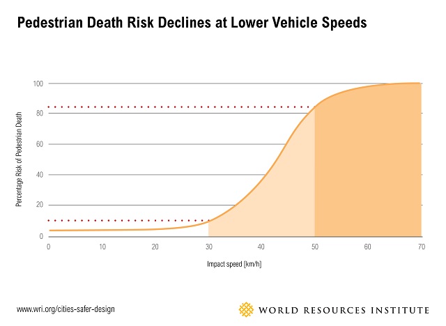
As we know from the Vision Zero research, a person hit by a vehicle going 20 km/h has a MUCH better chance of surviving the collision than a person hit by a vehicle at say, the report's recommended, "<40 km/h" - not to mention the reduced likelihood of a collision happening at all, if the speed limit through construction zones on Major Arterials and Collectors in Toronto's dense urban core were a standard, 30 km/h.
Added to this is the benefit to the City over the long term in lower road maintenance cost if the liabilities that construction companies face while doing City of Toronto contracts are lower due to a marked decrease of on-the-job injury and death from worker/private motor vehicle collisions. Worker injury due to through-traffic is a major concern for the Province of Ontario and the Road Construction Industry 7.
Michael Holloway Ward 30 Bikes Outreach Coordinator TTC Leslie Barns Construction Liaison Group
7 In 2012 Ontario Ministry of Labour conducted inspection blitzes at road construction sites to try and mitigate what the Ministry saw as an alarming trend in the increase in worker / private motor vehicle collisions at road-based construction sites (below, see quote from page 1, paragraph 3 - MOL Blitz Results 2012*):
Traffic control
In June, the MOL conducted an inspection blitz on the dangers of working around vehicles and large pieces of mobile equipment at construction sites, including roadwork projects. During this period, 944 orders were issued, 56 of which were stop-work orders. The orders were based on 573 field visits by inspectors. The orders issued most often were for
lack of protective headgear
failure to develop and use a traffic protection plan
failure to ensure workers and employer complied with the Occupational Health and Safety Act and regulations
The MOL chose this issue for its blitz because there had been so many injuries and fatalities in this kind of work. Between 2009 and 2011, four workers were killed or injured on construction sites and roadwork projects and fifteen workers were seriously injured.
The video is set to start at 1:49:45 when Councillor Janet Davis asks staff about Ward 30 Bikes' proposed amendment to reduce the speed in a shared roadway condition to 30 km/h; report author, Jacquelyn Hayward Gulati, Manager, Cycling Infrastructure & Programs - Transportation Services responds. (Click to 1:39:13 for the beginning of item PW19.4)
via Toronto Star, via FirstGulf - East Harbour's Broadview extension south through a proposed Transit Hub on the rail berm - with (typical of last-century city building) missing Active Transportation visioning
East Harbour is developer FirstGulf's new brand name for the UniLever Site at Lake Shore Boulevard and Don Roadway (the Don River). With progress being made on the numerous different elements integral to this massive city centre development south of Eastern and Broadview, East Harbour has been in the news quite a bit of late.
I'm on the working group representing Ward 30 Bikes.
Not included in these overviews is all the active transportation infrastructure we've been talking about at ~2 years of working group meetings.
We're advocating for a way to extend the Eastern Avenue Bike Lanes west from Logan across the valley through this project.
We're advocating for an east-west corridor for bicycles from Eastern at the rail bridge along the south side of the berm (integrated into the massive Transit Hub somehow) and across the valley to connect to the Lower Don River Trail and to Corktown Common and beyond (Richmond/Adelaide Bicycle corridor).
Early designs also include a north-south route along the west side of the property and then a connection to the bridge across the valley via said transit hub (which extends from the west side of the valley to the rail underpass at Eastern).
We also want to extend the Eastern Avenue Bike Lanes west of the rail underpass to Broadview - and somehow north from there to the Viaduct near Danforth/Broadview.
Broadview is to be extended south of Eastern through the site and into the Port Lands. We see this section of Broadview as a street with high quality separated bike infrastructure on it (as does the Port Lands Acceleration Initiative report).
City Council met last week and we're thrilled to report that the Woodbine Bike lanes were unanimously approved! Not much in Toronto's cycling world happens unanimously, so this is special!
It's also the result of some serious outreach efforts from our friends at Ward 31 and Ward 32 advocacy groups, the efforts of the local councillors who really pushed hard for this, and city staff who organized a massive public outreach.
And it's not just a painted line! Buffers and flexi posts! Is this the best that cycling infrastructure can be? No, not at all. It's unlikely Scandinavian traffic engineers are going to get any best practice tips from this. BUT its moving in the right direction. Buffers are better than single painted lanes. And buffers turn into flexi posts, flexi posts turn into curbs or planters. Curbs and planters turn into full fledged separated from vehicles paths like the waterfront trail.
Last week our event Bikes Mean Business was a huge success!
Left to Right: Brandon (Ward 30 Bikes), Jared (Cycle Toronto), Billy (Chair of Danforth Mosaic BIA and owner Red Rocket Coffee, Councillor Fletcher, Sylvia (Ward 30 Bikes), John (owner of Allens' and Dora's) - photo credit: Councillor Fletcher's office
This event was a collaboration between all the east end Ward groups within the #DanforthLovesBikes working group and Cycle Toronto. We pulled people from across the community and wider city to discuss and celebrate the amazing economic benefits of bike-friendly streets!
Yvonne Bambrick, author of The Urban Cycling Survival Guide and Executive Director of the Forest Hill Village BIA kindly MC'd our event.
Yvonne Bambrick introduces Billy Dertilis Chair of Danforth Mosaic BIA and owner of Red Rocket Coffee
The turnout was great - we had Dora's packed!
Councillor Janet Davis (Ward 31) and Councillor Paula Fletcher (Ward 30) front and center
First to speak was Councillor Paula Fletcher who gave her full support for studying bike lanes on Danforth. She talked about the collaborative work going on to improve bike parking (Danforth BIA + Ward 30 and Ward 29 bikes + her office), and she talked Bike Share. It's coming to the east side - scheduled for this year! And she reassured the audience that protection the viaduct lanes is something she is still pushing for.
Councillor Mary Margaret McMahon (Ward 32) followed up as did Councillor Janet Davis (Ward 32) who both gave enthusiastic words of support for a bike friendly Danforth that includes bike lanes!
Jacquelyn Hayward Gulati Manager of Cycling Infrastructure Programs from the City of Toronto staff kindly came out and spoke to the packed room about the 10 year bike plan and the process for consultation and collaboration. We were so fortunate to have city staff join us!
And then our host for the night spoke. John Maxwell owners of both Dora Keogh's and Allens:
John Maxwell business owner speaks to the crowd
A strong supporter for a bike friendly Danforth his words were particularly moving. He agreed with all the research that was presented, but added... there is more to life than business, right? He ended his speech with very thoughtful words about life just being better with people friendly streets.
Billy Dertilis owner of Red Rocket Coffee and Chair of the Danforth Mosaic BIA added with more words about businesses that do want to see a bike friendly Danforth. It was really fantastic to have local businesses sharing their support.
Jared Kolb from Cycle Toronto wrapped up the night speaking touching on the concepts of working through change.
What a night!
After all the speakers everyone had a chance to enjoy drinks and to chat. It was so good to see local Danforth BIA Executive Director Susan Puff in attendance, as well as owners of the Second Cup on Danforth and Dough Bakeshop. Riverdale Cleaners was there too. I saw some members of the Playter Estates Residents Association taking it all in, and a few from DECA. I'm sure there were many many more there too. The crowd was really diverse.
So behalf on all of us who planned this event, thank you to everyone who joined us that night!
Over the weekend City Staff from the Cycling Unit gave up a solid block of hours to meet with representatives from Cycle Toronto Ward Groups to talk about their latest draft map for the city. Thanks to those who joined us on Friday night to brainstorm ideas
There we are at a table covered in maps. pic: CycleToronto
Are we still talking about a DRAFT map? ya, we are. Its a long process, but we can report back that it is careful and with thoughtful planning. With a limited budget to spend each year, city wide projects need to be ranked to decide what happens when. So we don't always get what we want when we want it, but know that other parts of the city are being worked on.
Want more sooner? Demand a bigger budget! Submit your comments to Public Works Infrastructure Committee - NOW. The cycling budget will be discussed at the next meeting February 29th. Do it!
Back to the map, some interesting things:
- Eastern Ave over the DVP has something planned. Sorry to say we didn't get many details about what they want to do there, but there was a spark of excitement in their eyes. However, this one is a 'few years' away.
- Danforth, Danforth, Danforth! (sign the pledge if you haven't yet!). It's in the draft, it's been in every draft. And for our Ward, I'd say this is *the* project they want to focus on. ya!
Want to hear more? come to our next meeting to find out:
- to reduce the rate of increase in neighbourhood motor vehicle volumes
Ward 30 Bikes' "Eastern Avenue Working Group" is making steady progress on our submission to City Planning about the proposed StudioCentre development on the south side of Eastern Ave between Pape and Larchmount.
From our still-in-draft report, this is a snippet about the Bike Rooms indicated on the drawings near loading docks in 5 buildings:
Bike (parking) Rooms in drawings submitted by StudioCentre are located right next to loading docks. This is the worst place to put them.
Best Practice says they should be view-able from the street like an apartments' front entrance door --- and especially not in a narrow service alley shared with loading docks and a parking garage ramp connected to the street grid via a rear roadway intended mainly for solid waste and delivery trucks.
As an example of this (and other*) best practice - translated into a retail/office box development context, I sketched a better placed StudioCentre Bike Room on their most recently submitted ground elevation drawings (June 2015).
As an example, I moved the Bike Room in Building 03 (southwest corner of Eastern and new lower Caroline) such that it now it has:
Two sets of double wide doors right beside the main entrance to the buildings' Foyer (perhaps grocery store style sensor-opening sliding doors?);
Two doorways to the Foyer, one that leads directly to the elevator banks, and one that leads to the stairs (totally integrated);
Propose a glass street-front wall, and a glass divider wall between the Bike Room and the Foyer (this keeps 'eyes' on the Bike Room and advertises the developer's sustainable transportation amenity - which helps to create buy-in by tenants and employees);
Propose a washroom in each Bike Room - which should include a shower and lockers (might consider a cost effective, unisex facility: common counter and sinks; locking, single toilet rooms; locking shower room; a wall of half-high lockers).
* (and other best practice about bike parking) - separate motor vehicle spaces and bike spaces wherever possible; locate bike parking as close to the main entrance as possible; create a safe, accessible, well lit, calm egress to the amenity; create a warm, bright, visible, welcoming bike parking space - via:
A group of residents here in Ward30 got together a few years back to put their heads together on the increasing traffic problem in Riverdale. They've since put together a draft proposal that aims to reduce traffic speeds, reduce total vehicle volumes, and discourage non-residential use of local streets.
As advocates for safe streets, we couldn't be happier to see like minded neighbours put their volunteer blood, sweat, and tears into making Riverdale safer. We are thrilled with proposed speed reductions and bollards along the sidewalk in front of schools - great idea!
But, there are also some issues with the plan that need to be addressed. Reversals of one-way streets in the current plan may compromise the ability of people to get around safely on bikes. Even more troubling is that one part of the plan includes adding "island parking" to the north side of Riverdale Avenue.
Here's the problem with island parking
On-street island parking compromises pedestrian, cyclist and motorist safety by creating visibility barriers. People crossing the streets, both on foot and on bike, especially young children, become hidden to motorists. One study of child pedestrian injuries found that "the number of parked vehicles was the strongest risk factor on residential streets." Island parking could also make the entire roadway a "dooring" zone, putting cyclists at further risk. We need a solution based on evidence, not on creating a false sense of security.
We think this plan can be even better!
The solution: bike lanes
We've got something else that can narrow streets, benefit all road users... AND encourage less vehicle volumes. Bike lanes.73% of Torontonians say the lack of cycling infrastructure in the city is holding them back from riding more. 73%! We want to give people the infrastructure to meaningfully reduce vehicle volumes.
Even with negligible bike infrastructure, Riverdale is already a community of active cyclists:
Our proposal
Through a combination of bike lanes, we propose a bike route along Riverdale Ave / Boultbee Ave.
A bike route connecting Broadview to Jones Ave will:
narrow streets (a riverdale traffic calming group goal)
reduce vehicle volumes by encouraging other methods of transportation
establish a safe east-west cycling connection to the existing Jones Ave bike lanes
traffic calm the section of Riverdale in front of Pape Ave Junior School with protected bike lanes
provide a bike to school route for:
parents cycling with their kids to Pape Ave Junior School
parents cycling with their kids to Blake Street Junior School
students going to Earl Grey Middle School
students going to Riverdale Collegiate Institute
provide a safe bike connection to Riverdale Park East and the Lower Don Trail
(note, we assume that elementary school children ride along the sidewalk, and caregivers and parents ride safely beside them in the bike lanes)
We met with the traffic calming group hoping they would include our plans in their proposal. We were unfortunately disappointed to find that they did not put forward any bike routes in their draft proposal.
Riverdale is an awesome neighbourhood. I live here, my kids go to school here. And until our kids get drivers licenses, bikes will be primarily how they get around the neighbourhood. Will my 5 year old use a bike lane now? no... but when he's a teenager he will. All our teens will. Let's give them safe options to travel around our streets.
the Riverdale Ave bike route supports all users of our streets, not just motorists
We scouted the proposed route in November last year and then in February this year we went out with City of Toronto Cycling staff who have noted that it's a feasible route with no impact to parking.
Take action!
If you share our views and want to make this a reality, we encourage you to take action.
Attend the Riverdale Traffic Group community meeting Wednesday, May 13th, 7pm St. John’s Presbyterian Church, 415 Broadview Avenue
Make your voice heard, and ask for a bike route to be added to the plan, and make sure the final proposal achieves the goal of safer and more welcoming streets for everyone.
Did you make it out to a Jane's Walk this past weekend? Several Ward30bikes members were out at the Complete Streets Jane's Walk on Saturday:
Pape Station, start of walk
I think the topic of complete streets really resonates with the community as the turnout was great. The walk included many stops as we went from Pape Station down to Logan and Queen. At each stop the leader asked several participants read out prepared notecards detailing the desires of various users of streets (BIAs, cyclists, pedestrians, cafe owners, EMS workers etc,) so as a group we could reflect on all the competing desires of users.
What was lovely to see was the amount of cyclists out, and the amount of cycling related questions posed to the walk leader.
3rd stop: Withrow Park Strathcona Contraflow bike lane / bike trail through the park.
A question was even raised about how to get better coordination amongst the city departments so bike lanes don't get closed down to be used as temporary parking, under a film permit. There were a few shout outs to the City of Toronto's latest bike survey (do it!), and encouraging people to join Cycle Toronto. Although I think if this gets offered next year, we as Ward30bikes should ask the leader to mention our local group. Joining the city wide cycle advocacy is step 1, finding your local advocacy group that's working locally is step 2 (that, and we're a pretty fun bunch of people!)
Cyclists out for the Jane's Walk
Logan is an interesting street. The leader talked about how it's an unofficial slow street. We've got our ideas too that we are advocating to be put into the new City of Toronto Bike Plan. I live in this neighbourhood, I would say Logan is also an unofficial cycling contraflow street based on the amount of cyclists you see going the wrong way down the street. That's just how unappealing cycling down Carlaw can be.
Join Us! Sunday, May 3rd at 10:00 am - Leslie Grove Park (corner of Queen and Jones).
Ward 30 Bikes members Michael Holloway and Don Merriam will lead a walking description and discussion of Ryerson University, School of Urban & Regional Planning, Advanced Planning Studio Fall 2014 Class Report, "Connecting Greater Riverdale to the Lake".
In the report the 4th year Ryerson Planning students identified Leslie Street as a possible Quick Start option - and the only viable connection point from the neighbourhood across Lake Shore Boulevard and the Port Lands to the Waterfront.
This Jane's Walk will travel the southern portion of the Quick Start route that the Student team chose.
The walk will begin at Queen St E and Jones Avenue - the point at which the Jones Ave Bike Lanes ends - and then we'll take Rushbrooke down to Eastern Avenue. At this point the route includes a proposed Pedestrian/Cyclist refuge island at the bottom of Rushbrooke between the westerly and the easterly traffic lanes on Eastern Ave - and green painted crossing points connecting it from Rushbrooke to Mosley.
From Mosley down to the south side of the Plaza intersection 'Super Sharrows' is visioned. South of the Plaza Intersection the proposal visions narrowing the existing traffic lanes and turn lanes, and installing 1.5m wide Bike Lane - northbound and southbound.
It's complicated. But it appears to be the best solution so far that doesn't remove traffic lanes or parking.
Last week Councillor Paula Fletcher and her office hosted a Planning Matters Open House. The open house included representatives from the city, and local developers to speak about the on going and planned projects for our ward. Portlands, Broaview Ave extension, Downtown relief line, the fate of the Gardiner, new condo developments - all there in one room.
It was a great community information night, and gave residents the opportunity to ask questions and make suggestions directly to the people working on these projects.
And Ward30bike was there! Questioning the plans, reiterating the desire for safe cycle infrastructure to the waterfront (had a great chat with the city planner about the Broadview Ave extension plans and getting access to that little Ward30 jewel Cherry Beach), bike parking along Queen St, and cycle connections across the DVP. It was also great to see that Councilor Fletcher's office invited a familiar face from the City of Toronto cycling department. When you get all these people in one room you can hear things like: '...well we would want to work with the city on that bike lane connection' ' ... so you mean me?' and friendly laughter.
Aside from what we were advocating, it was nice to hear so many residents also express their desires for cycling infrastructure incorporation into these projects. On the positive, Streetcar developments has in their plans underground weather protected bike parking for residents of their condos. Streetcar also has some ideas on their presentation board for building multi-use connections to some new (to be developed by the city) park space nestled around the DVP eastern Ave pocket (like a smaller version of Corktown Common). They had some big ideas up on their board including a new pedestrian / cycle bridge connection across the dvp parallel to Eastern Ave. The reality (and funding!!) of such an ambitious idea remains to be seen, but when they dream, they dream in fully accessible urban planning.
A note for councilor, I would encourage that funding and implementing these multi-use connections, parklands and greenery be conditional on any development permits. As one resident that night said, it would be a tragedy for our neighbourhood if this development took shape like the "ghetto-ized" concrete Liberty Village.
Speaking of Liberty Village, overheard was a few residents expressing concern of the potential congestion on the Queen Streetcar line that could result from all the planned condo development. Definitely a concern that Queen could become the new King Streetcar. The city of Toronto's planning department representative confirmed that they are running traffic studies for the area, so it's a start.
Finally a note of shame on the presentation of the former Jilly's landmark. I wish I caught a photo of the Streetcar Developments presentation board that showed Queen Street with a fully redeveloped Jilly's. The street scene showed 2 streetcars slinking down the middle of the road. On the north side two cyclists pedaled joyously. On the south side a carefree jogger crossed the street, with their delightful golden retriever in tow. Pedestrians lined the streets casually walking and enjoying this car free utopia.
I questioned the developer. 'Are you proposing that Queen East become car free? ' 'Oh no. Hmm, you know developers... we'll get that picture changed'.
Cycle Toronto - safe streets, a healthy city, a vibrant voice - Thursday, June 12th Dear _________, Please e-mail the Public Works and Infrastructure Committee (PWIC) today to help make the proposed bike lane on Dixon Avenue a reality, and improve cycling in Toronto's east end! The next PWIC meeting takes place on June 18th, and the Dixon Ave staff report is one of the items being voted on. If PWIC adopts the report, it will go to Council on July 8th. Adding a lane on Dixon will provide a valuable neighbourhood connection between Woodbine Avenue and Kingston Road. Ward 32 Spokes and Cycle Toronto fully support the staff report - it's recommendations are strong and will make a very positive contribution to cycling in our community. Please e-mail pwic@toronto.ca with your support for the item before June 17th at 4pm. When writing your email, don’t hesitate to include your personal story. Consider including your mailing address, as messages from local and Toronto residents carry more weight. Finally include item number PW32.5 in the subject line, and cc: info@cycleto.ca and ward32@cycleto.ca.
Summary of the Staff Report:
Currently, Dixon Ave. is westbound only between Lockwood to Kingston and eastbound only between Lockwood and Woodbine. See the map of the area. - Between the westbound only section of Dixon (Kingston to Lockwood), the report recommends an eastbound contra-flow bike lane located on the south side of the street next to on-street parking. *Cyclists travelling westbound will continue to use the shared traffic lane as they do now. - Between the eastbound only section of Dixon (Lockwood to Woodbine) the report recommends a westbound contra-flow bike lane on the north side of the street, away from the on street parking. *Cyclists travelling eastbound will continue to use the shared traffic lane as they do now. - No changes are recommended to on street parking along the entire length of Dixon Avenue. The installation of these two sections of contra-flow bike lane will allow cyclists to use Dixon Avenue as a two way street. These small additions to the area’s cycling infrastructure will provide valuable neighbourhood connections for cyclists of all ages who wish to avoid cycling on busy arterial roadways and major intersections.
Relevant Resources:
1) The PWIC agenda item for Dixon (PW32.5) 2) Staff presentation boards to Public Open House on the Dixon Avenue Bicycle Lane (PDF) 3) Background on “contra-flow” bike lanes If you have any questions, please email ward32@cycleto.ca
---
My Letter to PWIC:
(Use this as a template replacing my story about Dixon Ave - with your story about Dixon Ave).
TO: pwic@toronto.ca Cc: info@cycleto.ca, ward_30@cycleto.ca, ward32@cycleto.ca Subject Line: PW32.5 - Contra-flow Bicycle Lanes on Dixon Avenue
Public Works and Infrastructure Committee Members and Chair,
I am writing in support of an item the Committee is to consider at your meeting scheduled for June 18, 2014 - a Transportation Staff recommendation for the installation of contra-flow bicycle lanes on Dixon Avenue, from Kingston Road to Woodbine Avenue.
I am a year 'round utility and recreational cyclist. I have never had a drivers license and I do not own a motor vehicle. As a resident of Ward 30 nearby Dundas Street on Jones Avenue, the Dundas Bike Lanes are a very important transportation route for me. When I reach Kingston Road on the Dundas Bike Lane eastbound, I am forced (due to the traffic calming one-ways on Dixon), to either turn south or north on Kingston Road - a busy and fast moving Avenue with no Bicycle Infrastructure.
Annoyingly, the south bound route forces me to travel back on my easterly route in a south-westerly direction - back to Queen and Kingston Rd. - at which point I then take Queen Street East (a fast moving, busy Avenue) back eastbound over to Lockwood; then left off Queen back up northbound onto the On-Street Connection that is Dixon Avenue (which notably - gets me to Norway Avenue and Woodbine Avenue - another On-Street route on my path east - that I often take all the way over to Scarborough Road and beyond - all the way on quiet residential streets!).
The northern route around the Dixon Avenue barrier on the other hand, is on a section of Kingston Road that is marked by a steep upward incline, and a curve in the roadway at which point, simultaneously, motor vehicle traffic is travelling at a high rate of speed, accelerating and merging - and where I feel like the parked cars along the south side of the Avenue there create a pinch-point for cyclists between the parking zone and the motor vehicle traffic there. A dangerous stretch to be sure.
Thus I urge the Public Works and Infrastructure Committee to accept the Staff Report and send this recommendation for the installation of contra-flow bicycle lanes on Dixon Avenue from Kingston Road to Woodbine Avenue to City Council for a vote.
Sincerely, Michael Holloway # Jones Avenue, Leslieville, Toronto
---
Use this as a template replacing my story about Dixon Ave with your story about Dixon Ave..
The Queen/Leslie closure detours cars and buses Jones to Greenwood; and Street Cars from Broadview to Coxwell.
The Queen/Leslie closure May through June, offers an opportunity here in Leslieville to try a Pedestrian Mall on our neighbourhood's Main Street.
Map showing area of possible "Leslieville Open Streets" Weekends during the Queen St closure
Open Streets Leslieville
Ward 30 Bikes notes that Queen Street from Jones to Greenwood could be seen as a Pedestrian Mall for May and June. Like the "Open Streets" idea that the City is trying this year on Bloor Street from High Park to Sherbourne1 - this is an opportunity to create a vibrant pedestrian centred street for a couple of months.
We note that businesses are likely trying to get as much car traffic into the dead ends on both sides of the blockage - they need the access for deliveries, and for many, not just businesses, off-peak on-street parking.
The Leslieville BIA is planning a Festival in the closure area one weekend in June. Let's expand that good idea.
Every weekend in May and June we could completely block Queen Street - at Jones and at Greenwood - and allow only pedestrian traffic into the area. Businesses could push their business concepts out their front doors and onto the sidewalks in some fashion. People would use the street to walk on - just like the Taste of the Danforth weekend; except this would happen Every Weekend for the duration of the construction closure!
This Open Streets - Taste of Leslieville idea could actually increase business!
Shops all along Queen Street East - and especially from Broadview to Coxwell - are going to experience reduced traffic flows past their font doors during the closure. The Greenwood - Jones area has the advantage that the road is also actually closed. We can take advantage of that and do a Yonge Street style Pedestrian Mall thing for 6 weekends in a row starting this coming weekend!
This is not a half-baked idea out of nowhere from us here at Ward 30 bBikes. This idea is central to our thinking around an idea called "Liveable Cities". Liveable Cities include "Complete Streets" - streets that have narrower traffic lanes, wider sidewalks - and bike lanes. Room on our roadways for more kinds of activities - not just commuter car traffic passing through. An Open Street Weekend is a way to help people vision what a Complete Street could do for a neighbourhood. What a Liveable City might 'feel' like.
The massive highway-like traffic flows on Queen everyday, all through the day (almost) - make Queen the kind of street people like to stay away from if they can help it, during the peak hours. It's only at night when traffic volumes subside that everyone comes out for a casual walk after dinner - or whatever it is they like to do on our neighbourhood's Main Street.
Now we have an opportunity to experience this All Day - Saturday and Sunday - for 6 weekends on a row! If it works, we might even want to expand the idea to Friday's as well!
It is quite likely that this concept just might result in an increase in business on Queen! Locals will come out to support it at first; and then as the news spreads, folks from other neighbourhoods would grab the Bus or Walk or Bike over to Jones - or west to Greenwood - and arrive there just to experience the thing.
Leslieville Open Streets Weekends!
Let's turns this road closure thing on it's head. This is a great opportunity to try something that we couldn't try at any other time - ever.
This is a unique opportunity.
The noisy part of the hole they're making at Queen and Leslie is already almost over. Next comes the task of laying the concrete bed; and then the complex 3/4 Grand track placement - and then more concrete pouring. The street should be relatively quiet these next two months - Especially on weekends!
Come on - let's just do this thing. Leslieville Open Streets Weekends!
Open Streets TO (Original plan: High Park to Withrow Park - scaled back by Council's Economic Development Committee last month) | http://www.openstreetsto.org/